Period: since 2017
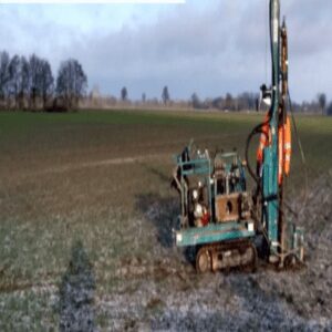
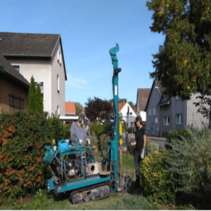
Field of activity: Explosive ordnance clearance
Scope of services:
- Evaluation of existing basic data, HgR, aerial photo analyses and construction documents incl. deficit analysis
- Planning of test field investigations for subsequent CMR measures in phases B and C in accordance with BFR CMR
- Creation of a project GIS for the documentation of all KMR measures and their
Results incl. update
- Development of a KM exploration concept for preliminary test field investigations on water and land areas (including Cs vapour sensors, TDEM methods, sonar and echo sounder)
- Compilation of the service description and the bill of quantities incl.
Cost estimation and transfer in GAEB format
- Quality control and local construction supervision
- Specialist construction management to support the client
- Evaluating and analysing the sounding data
- Development of recommendations for KM exploration in the run-up to the planned construction measures based on the test field exploration results
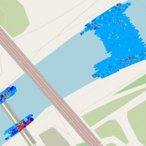
As part of the replacement construction of the old Levensau High Bridge and the expansion of the Kiel Canal (NOK) from kilometre 93.2 to 94.2, the existing navigation channel is to be widened by reclaiming the banks and dredging the bed. In preparation for this, geophysical investigations are to be carried out in this section of the route in order to
- unexploded munitions from the Second World War as individual anomalies
- Explosive ordnance from ammunition dumps as individual anomalies or as possible
Load ranges
- detect and identify scrapped or other areas that cannot be analysed.
The investigation services and subsequent salvage services are to be put out to tender by the Federal Waterways and Shipping Administration (WSV). The investigation area is largely under water and is covered with armourstone containing iron silicate. The bank area from the water change zone to the embankment shoulder is a paved area of armourstone (granite) with a slag rock backfill on top. The plans for the test field soundings envisage the use of various echo sounding and sonar methods to investigate the bed of the watercourse. Subsequently, geomagnetic surface soundings will be carried out using total field magnetometers and underwater TDEM soundings. The comparison of all available results will provide reliable information on the applicability of the individual methods and their limitations. The measurement data from the 2019/2020 soundings are currently being analysed in detail.